


Chinese and Russian Satellite Feeds Aid Iranian War Effort
At the height of the Houthis’ war on shipping in the Red Sea and Gulf of Aden, it was apparent that under IRGC tutelage, the Houthis made use of an integrated surveillance network to back up their targeting efforts. This was constructed using unsophisticated local collection efforts, such as reporting from fishing boats and coastal radar sites. But it also relied on IRGC-fed intelligence, derived from imagery satellites and strategically-positioned spy ships in the Red Sea, such as the MV Behshad (IMO 9167289). One of the main roles of the senior IRGC officer posted to Sana’a and sitting on the Houthis' Jihad Council was to act as the conduit for such intelligence.
Satellite imagery fed to the Houthis through the IRGC came from both Chinese and Russian sources.
The Iranians have worked with the Russians for some time on developing their Khayyam satellite, jointly built with the Russians and based on their Kanopus-V imagery satellite. Given the co-development, Khayyam and Kanopus-V satellites have been operated as a single constellation, providing each party with wider imaging opportunities and sharing costs for doing so. With satellites in 300-mile low earth orbit, this would give the Iranians access to 1m resolution imagery, visiting any specific point of interest about four times a day, albeit the satellite then needs to be in position to download the imagery back to earth. Such a capability would be regarded in the western intelligence community as being useful but antiquated - adequate for precise targeting of static targets such as the U.S. Embassy in Riyadh and the Aramco refinery at Ras Tanura. The constellation could cue the targeting process for targets at sea, but for identification and direct engagement, the Houthis (or the Iranians) would need to track targets with skiffs, fishing boats, or active radar systems.
However, the Iranians and the Houthis also have had access to the latest Chinese technology, in the form of imagery provided by Chang Guang satellites, fed from a network of 300 Jilin-1 mini-satellites in 375-mile deep orbit. This system can produce up to 0.5-meter resolution imagery, including optical, hyperspectral, and live video of moving targets. Chinese military-standard communications equipment capable of transmitting such intelligence was intercepted by the U.S. Coast Guard en route to the Houthis on January 28, 2025.
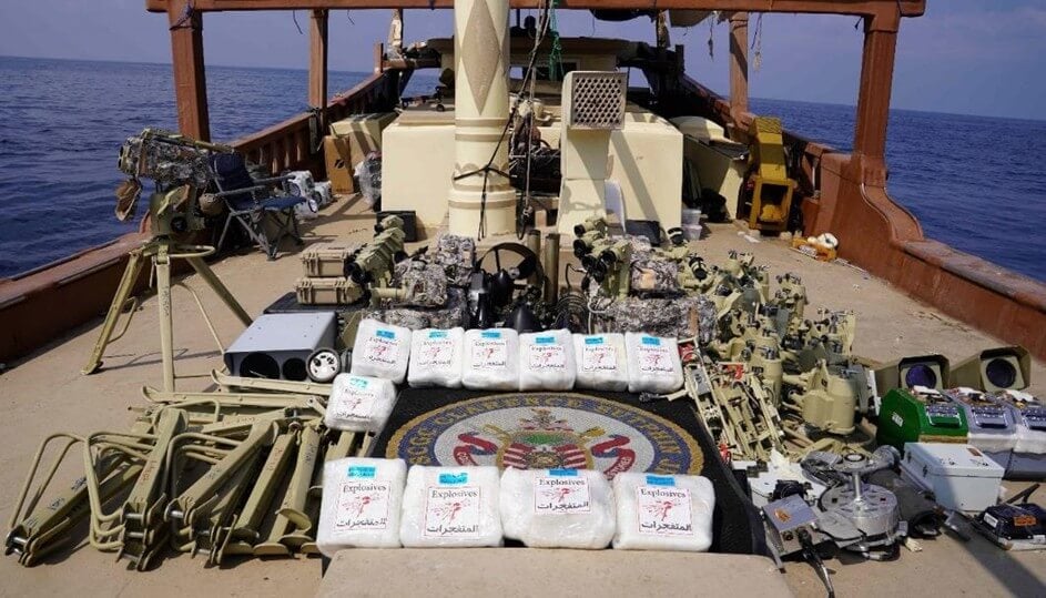
On January 28, 2025, the U.S. Coast Guard cutter Clarence Sutphin Jr seized a consignment of Chinese military-grade communication and network equipment en route to the Houthis (CENTCOM)
To give themselves some cover for passing military-grade targeting data to the Iranians since the start of Operation Epic Fury, the Chinese company MizarVision has been publishing high-quality annotated imagery of American targets, describing it as “open source” intelligence.
MizarVision, based in Shanghai and which only began publishing imagery a week before Operation Epic Fury started, does not have its own satellites, and appears to be procuring, processing, and publishing its analyzed imagery without charge to the end-user, clearly identifying it as a Chinese government front company. It may indeed even be procuring imagery from Western commercial providers, which may explain why such providers appear on March 3 to have turned off their postings of the conflict areas.
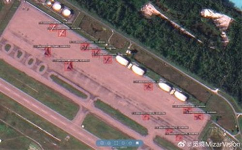
MizarVision annotated imagery of the South Pan at Diego Garcia (MizarVision)

that matters most
Get the latest maritime news delivered to your inbox daily.
MizarVision has, in the last week, published imagery of several U.S.-associated targets in Israel, Jordan, Bahrain, and Saudi Arabia, which, within a very short space of time, have then been targeted by the Iranians.
Content Original Link:
" target="_blank">


